

Synopsis Meteo: A dry and stable airmass covers the region for today with a slight possibility for rain. As storm approaches the regional area, winds will shift to the north and later west into tomorrow Thursday with increasing chance for rain.
Albeit the cyclone is foreseen to pass at a safe distance from the island, the time span around the area will be sufficient to promote a choppy local sea condition, in particular along the southern coasts. Therefore, boaters and other marine interest should safeguard their properties in this area.
Sea conditions: Today light to moderate waves 0.5 tot 1.5 meter waves. Local seas will begin build and become somewhat rougher as the cyclone approaches the region north of the island. Seas will become moderate to locally fairly rough with waves of 3 to 8 foot. A Small Craft Advisory may be necessary on Thursday.
Significant tropical weather systems:
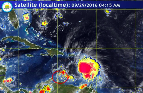
Tropical storm Matthew is foreseen to pass as a hurricane at a safe distance from the local region sometime by the night of Thursday into Friday. Tropical storm Matthew is presently located at 775 kilometer east-northeast of Curaçao over the island chain in the eastern Caribbean Sea. The Meteorological Department of Curaçao will continue to keep the storm under a close observation. Please refer to the Tropical Cyclone Bulletin for further information on this system.
Seas: Waves will start to build gradually later on Thursday afternoon and reach maximum heights of 2 to 3 meters (rough) in a period between Thursday evening and Friday afternoon. Depending on the wind direction all coasts can expect high wave action when the wind is blowing onshore. Northeasterly swells will start to build on Thursday evening. A Small Craft Advisory may be required on Thursday afternoon.
Rainfall: Occasional thundershower activity is expected, starting on Thursday evening with periods of rain between Friday and Saturday morning. Total expected rainfall amounts will be between 50 and 150 mm. Higher amounts are possible in some locations. With those expected amounts some flooding in the usual areas is likely to occur.
Discussion: According to the latest available model guidance, the center of Tropical Storm Matthew is now expected to pass at a greater distance form our island. The cyclone is expected to pass at a distance of about 250 kilometers north of Curaçao during late Thursday or early on Friday.
Tropical storm Matthew is foreseen to pass as a hurricane at a safe distance from the local region sometime by the night of Thursday into Friday. Tropical storm Matthew is presently located at 775 kilometer east-northeast of Curaçao over the island chain in the eastern Caribbean Sea. The Meteorological Department of Curaçao will continue to keep the storm under a close observation. Please refer to the Tropical Cyclone Bulletin for further information on this system.
Bron: Meteo
De niet toegestane tekens waren de SHIFT toets in combinatie met de toetsen 1234567890-=.
Als Insel Air het moderatieteam van de Knipselkrant had, zou Edward Heerenveen geen enkele mail meer krijgen.
Beste Hans,
Het moderatie team verwijderd dit soort toets combinaties doel bewust na een melding van onze software. Ook kunnen dergelijke toets combinaties een melding geven van Spam Robots waardoor het bericht uberhaupt niet openbaar wordt doch in de Spam folder verdwijnt.
Met vriendelijke groet,
Security
InselAir wishes to advise that due to impending weather forecast around the northern and southern Caribbean islands flight schedules might be impacted. Customers during these dates may contact InselAir Call Center at (+5999) 737 0444 or check the status of their flight here: http://www.fly-inselair.com/flightstatus.
This site can’t be reached
http://www.fly-inselair.co’s server DNS address could not be found.
———————————————–
Niet toegestane teken verwijderd
Moderatie Team